How to Check Your Elevation and Flood Risk
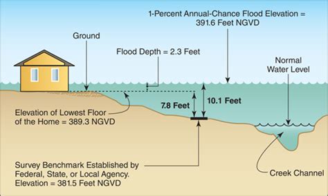
Knowing your property's elevation and flood risk is crucial for homeowners and prospective buyers. Understanding these factors can significantly impact insurance premiums, home safety, and even property value. This guide provides a straightforward approach to determining both.
Understanding Elevation and its Importance
Your elevation, simply put, is your property's height above sea level. This seemingly simple number plays a vital role in assessing flood risk. Higher elevations generally correlate with a lower risk of flooding, though local geography and drainage systems heavily influence the actual risk. Understanding your elevation is the first step in assessing your vulnerability.
Determining Your Property's Elevation: Multiple Methods
Several methods exist for determining your property's elevation, each offering varying levels of accuracy and convenience:
1. Using Online Mapping Tools
Several free online tools leverage readily available elevation data to provide approximate elevations. These tools often use satellite imagery and topographical maps. Popular options include:
- Google Earth: Provides a visual representation of your property and allows you to check the elevation with a simple click. Remember that accuracy can vary.
- USGS (United States Geological Survey) National Map: A more precise source for elevation data, though it may require more technical navigation.
- Other Online Mapping Services: Numerous other online map services offer elevation data; research to find one suitable for your needs and location.
Note: Online tools provide estimates. For critical applications, consider more precise methods.
2. Consulting Local Government Resources
Your local government, such as your county assessor's office or planning department, likely possesses highly accurate elevation data for your property. Contacting them is a reliable way to obtain this information. They might have property records containing precise elevation measurements. This is often the most reliable method.
3. Hiring a Surveyor
For the most accurate elevation measurement, hiring a professional surveyor is the recommended option. Surveyors use sophisticated equipment to precisely determine your property's elevation. This is especially crucial for construction projects or detailed flood risk assessments. This is the most accurate but also the most expensive method.
Assessing Your Flood Risk
Once you know your elevation, you can begin to assess your flood risk. However, elevation alone isn't the sole determining factor. Other critical elements include:
Factors Affecting Flood Risk Beyond Elevation:
- Proximity to Water Bodies: Homes near rivers, lakes, or oceans are inherently more vulnerable to flooding, regardless of elevation.
- Drainage Systems: Local drainage infrastructure significantly impacts flood risk. Poor drainage can increase flooding even in higher-elevation areas.
- Historical Flood Data: Check historical flood maps to see if your property has been affected by flooding in the past. This information is often available through your local government or the FEMA (Federal Emergency Management Agency) website.
- Soil Type: The type of soil on your property influences how well it absorbs water, affecting flood susceptibility.
Utilizing FEMA Flood Maps
The Federal Emergency Management Agency (FEMA) provides crucial flood risk information through its Flood Map Service Center. These maps delineate floodplains and show areas with varying levels of flood risk. Checking your property's location on a FEMA flood map is essential for understanding your risk.
Remember: This information is for guidance. Always consult with professionals for crucial decisions related to your property and flood risk.
Conclusion: Proactive Planning is Key
Understanding your property's elevation and assessing your flood risk is a crucial step in responsible homeownership. By utilizing the methods outlined above and considering all contributing factors, you can make informed decisions to protect your property and family from potential flooding. Proactive planning can save you significant costs and heartache in the long run.
